Gap Mills Loop
Overview
Two long climbs of Peters Mountain with fairly flat riding in between. Definitely recommend riding it in a clockwise direction.
Length: 36.9Miles
Climbing: 2,887 Feet
Rating: 3.3
Climbing:Per Miles: 78
Location
This ride is on the Eastern edge of Monroe County in southern West Virginia and ventures briefly into Virginia. Gap Mills, and Sweet Springs, West Virginia and Paint Bank, Va. can be starting places.
PDF Map and Turn List
Slide Show of route.
Ride with GPS file of route created by George Cook
General Description
This ride features two long climbs separated by two relatively flat sections.
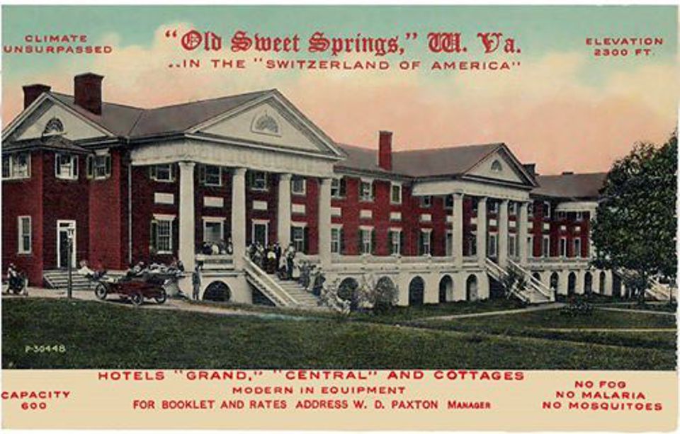
Gap Mills to Sweet Springs has a gradual rise as you climb to perhaps the easiest crossing of a continental divide in the United States, and then a gradual descend to Sweet Springs. When you get to Sweet Springs, you will want to continue one eighth mile past the route 311 turn to view the historic Sweet Springs Resort, designed by Thomas Jefferson, before returning back to route 311.
Sweet Springs, WV to Paint Bank, Va. features the climb of Peters Mt.. The main part of the climb is 2.6 miles averaging 6% and going up to 9
% in places,gaining 834 feet of elevation at the Virginia state line. It is easier toward the top. Then you enjoy a 3.3 mile descent into Paint Bank.
Paint Bank to Route 15 (Limestone Hill Road). At Paint Bank you will pick up Virginia route 600 that becomes WV county 17 when you enter West Virginia again. that will lead to the turn to Route 15 Limestone Hill Road. This is a flat cruise along what was a former railroad grade (Potts Branch of the Norfolk and Western). Beware of spinning out your legs before the climb of Limestone hill.
Route 15 to Gap Mills: After the nice cruise down Potts Creek, you will begin the second climb of Peters Mountain on Limestone Hill Road. This is a 3.5 miles climb, gaining 1,235 feet with an average gradient of 6.8 withs sections up to 10%. At the top of the climb will be the sign for the Hanging Rock Observatory Hanging Rock Observatory . You then have a steeper descent of 1.5 miles averaging 10% with sections of 12% or more before making a right at the bottom of the hill onto Zenith Road and have a rolling 3.6 miles back to Gap Mills.
PDF Map and Turn List.
Items of Interest Along the Route
 The most impressive attraction, which is just off the route a short distance, is the old Sweet Springs Resort in Sweet Springs. The main building was designed by Thomas Jefferson. This was part of the mountain resort circuit that included the Greenbrier, Salt Sulphur Springs, Red Sulphur Springs, Blue Sulphur Springs, in West Virginia, and Hot Springs and the Homestead, in Virginia.
Along Potts Creek is a buffalo ranch. You can usually observe buffalo grazing in one or more of the pastures, though they may not be near the road. Look for the stronger than normal fencing.
The Hanging Rock Observatory is a great place to view Raptors, especially during migration periods. It is a 0.9 mile hike off of the paved road.
Andrew S. Rowan, who was born in Gap Mills, made a perilous trip to Cuba to deliver a message from President McKinley to the rebel leader Garcia. His exploits were chronicled in the widely distributed pamphlet "A Message to Garcia." When the state of West Virginia bought the Sweet Springs Resort to serve as an old age home, it was renamed in Andrew S. Rowan's honor.
Proclamation Line of 1763 established a boundary that was suppose to restrict western expansion. It was delineated by the continental divide that is crossed between Gap Mills and Sweet Springs.
Water and Food
Along the route, public food and water sources are limited to Gap Mills and Paint Bank. In Gap Mills, there is Kitchen Creek Bakery and the Cheese and More Shop which offers sandwiches. In Paint Bank, there is the Swinging Bridge restaurant and a general store. The Monroe County tourism site provides a listing of area restaurants..
Lodging and Camping
Monroe County Lodging
Camping is available close to the ride at Moncove Lake State Park.
Willow Bend Bed and Breakfast
Disclaimer
The listing of routes on this site is not a guarantee of the safety of the route. Cycling has inherent risks and riders skills vary. Traffic conditions vary by time of day, season and local events. Road conditions can vary and change and may change dramatically over one winter season. Riders need to ride within their capabilities and be alert for road hazards and traffic at all times.
Copyright Notice:
This site, maps, photos and all materials created for this site are copyright of the author unless otherwise noted. They may NOT be posted on other sites or reproduced for sale or profit, without specific permission of the author. However, the maps and turn lists may be down loaded for personal, non profit use.


 Designed by Thomas Jefferson


 Buffalo ranch along Virginia 600.


 1
1 2
2 3
3 4
4 5
5 6
6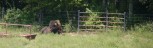 7
7 8
8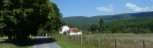 9
9 10
10