Lowell - Johnsons Crossroads Loop
Overview
 Length: 27.4 Miles
Climbing: 2,100 Feet
Rating: 2.4
Climbing Per Mile: 77 Feet
Location
This ride is in northeastern Monroe County and western Summers County in southern West Virginia. The nearest incorporated town is Alderson.
PDF Map and Turn List
In the left column, under "Related Links", you will find links to the WV State Road Commission detailed county maps that cover this ride.
General Description
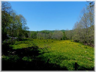
Like most of the rides in Monroe County, the route doesn't touch on any real populated communities. Place names on the route serve more as location references then population centers. Views of farms and forest reward the rider for his efforts. The route has a few miles of flat riding, but for the most part is hilly. There is no real preference in riding direction, though counterclockwise may have some steeper gradients. With the exception of 3.9 miles of State 3, the route is on single lane roads. This route can be combined with the Clayton Loop to make a longer ride.
Start: A convenient place to start is the church in Lowell. From route 3 in Pence Springs, go 2.6 miles on county route 15.
Riding in a clockwise direction and leaving from Lowell, you begin climbing along Kelly Creek on 15/1 topping out at the junction with 15/3. Continuing on 15/1 you skirt along the northern part of Wolf Creek Mountain before arriving at the junction with state route 3. Heading east on route 3, you enjoy a flat stretch along the wide valley of Wolf Creek before coming to a climb and descent as the route leaves Wolf Creek for a while.
Turning off of route 3 onto Co. 10, you continue to follow Wolf Creek to its source with the climbing getting steeper as you approach Johnson Crossroads. As the name implies, Johnson Crossroads was a prominent crossing of roads in the county. Now only the bike route is the only public route through the area. The fact that Co. 10 becomes Co. 14 belies the previous history of the routes through the area. You have a fairly steep climb out of Johnsons Crossroads up to Co. 7
Taking a left on Co. 7, you have a mostly downhill descent to Wayside where you take a right on Co. 9. On Co. 9 you have a steep climb before reaching the county line where the road becomes Co. 19. At the junction with Co. 17, you take a right and have a steep descent down to the Greenbrier River where you take a right onto Co. 15/2 that you follow back to Lowell.
PDF Map and Turn List.
This slides how link only covers the shorter route starting near Wolfcreek on Co. 10 and going thru Creamery rather than Wayside.
Items of Interest Along the Route
There are no significant attractions on this route other than the scenery. The cemetery at Johnsons Crossroads is interesting to get an idea of the early settlement of the area. See yellow highlight on this 1883 Map of Monroe Co.
The town of Talcott is just off this route on state route 3. The Big Bend Tunnel is the reported site of the contest between John Henry and the steam drill. You might want to visit the John Henry Statue on State Route 3 outside of Talcott.
Pence Springs is nearby and an easy visit. The old "springs" resort is now the home of the private Greenbrier Academy for Girls.
Water and Food
There are no public stores or restaurants on the route. Alderson is the nearest incorporated town with some restaurants and stores. There is a store in Pence Springs on State Route 3.
Lodging and Camping
Monroe County Lodging
Camping is available at Moncove Lake State Park and the private Greenbrier River Campground.
Disclaimer
The listing of routes on this site is not a guarantee of the safety of the route. Cycling has inherent risks and riders skills vary. Traffic conditions vary by time of day, season and local events. Road conditions can vary and change and may change dramatically over one winter season. Riders need to ride within their capabilities and be alert for road hazards and traffic at all times.
Copyright Notice:
This site, maps, photos and all materials created for this site are copyright of the author unless otherwise noted. They may NOT be posted on other sites or reproduced for sale or profit, without specific permission of the author. However, the maps and turn lists may be down loaded for personal, non profit use.