Macomber Loop
Overview
 Length: 40.3 Miles
Climbing: 3,610 Feet
Rating: 3.8
Climbing per Mile: 90
This is a shorter version of the St. George Loop. It offers great vistas and plenty of climbing.
This loop covers northern Tucker and southern Preston counties. For the 3,600 feet of climbing, you are rewarded with some great vistas climbing Location Road and across Stemple Ridge.
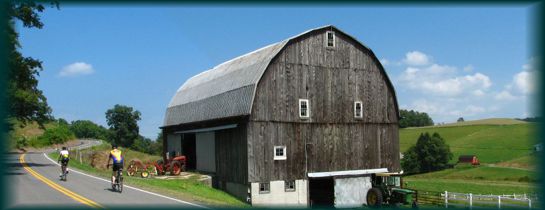
Location: This ride is in northern Tucker and southern Preston Counties and is a beautiful route through farm county and forest. The communities of St. George, Aurora, Macomber, and Etam are along the route.
The climbing on this route rewards you with outstanding vistas. This loop is a shorter version of the St. George loop. A large portion of the route is on two lane stripped roads, but traffic is usually moderate to light. Starting in St. George, also puts the majority of the climbing in the first half of the ride.
PDF Map and Turn List
Ride with GPS
Slideshow of St. George, Aurora, Macomber, St. George Portion.
General Route Description
 St. George to Macomber
Starting in St. George, you immediately begin climbing up Location Road. The first five miles of the climb is a very manageable 5 - 8 percent grade. You then have a flat and short downhill section before the hard final 3 miles of the climb of between 8 - 10 percent. Fortunately, you do not have to get to the top before you start enjoying some great views to take your mind off the climb.
After topping out climb, you enjoy a little downhill before arriving at the intersection with Tucker Co. 3. Taking a right, you head out the rolling Stemple Ridge and enter Preston County and Tucker Co. 3 becomes Preston Co. 112. After seven miles of “rolling” terrain, you arrive in Aurora and the intersection with U.S. 50. Some of these “rolls” are significant but the great vistas continue to distract you. At the intersection is a restaurant where you can get water (assuming they are open). Cathedral State Park is a couple miles off course to the right here on route 50.
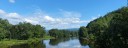
Turning left on route 50, you have a flat roll thru the community of Aurora. When you see the sign “All Trucks Must Stop” you know you are getting close to the descent. The descent is a steep twisting descent so control your speed and watch for gravel in the turns. After three miles, you are at the bottom and you are riding along the Cheat River. After crossing the Cheat River, you arrive at the small community at Macomber.
Macomber to St. George:
Arriving in Macomber, Route 72 from Rowlesburg comes in from the right and in another 1/8 mile, you turn left on Route 72 and head back toward St. George. Leaving Macomber, you begin a gradual ascent along Buffalo Creek as Sinclaire Ridge separates you from the Cheat River. As you arrive in Etam, you will notice the AT&T radio communication telescopes. Just after you pass this facility, you begin a mile plus climb of Sinclaire Ridge, the first of three climbs between between Macomber and St. George. Topping Sinclaire Ridge, you reenter Tucker County and descent to the Cheat River again.
After riding along the Cheat River for a while you have another shorter (0.4 m) climb and descent. The final 0.6 mile climb shortcuts a bend in the river and then you have an easy roll into St. George.
Food and water sources.
There is a new store, Patriots Four, that opened in 2013 near St. George on the route open Wednesday - Sunday. Being new, I do not know the hours of operation. If you are going to depend on them as a source of food and water, I would contact them first.
There is a restuarant at intersection with Route 50 at Aurora, but no guarantee of it operating hours, or even its continued operation.
Cathdral State Park is a coiuple miles off the route at Aurora to the right on route 50, and should have water available.
Items of Interest Along the Route:
The scenery is the main item of interest along this route. The combination of high mountain vistas and balanced. Cathedral State Park is two miles off the route, if you have the time and legs to take it in. The large satellite dishes of the Etam Earth Station, will surely catch your eye.
Acknowledgements
Country Roads Cyclists bike club introduced the ride to me.
Disclaimer
The listing of routes on this site is not a guarantee of the safety of the route. Cycling has inherent risks and riders skills vary. Traffic conditions vary by time of day, season and local events. Road conditions can vary and change and may change dramatically over one winter season. Riders need to ride within their capabilities and be alert for road hazards and traffic at all times.
Copyright Notice:
This site, maps, photos and all materials created for this site are copyright of the author unless otherwise noted. They may NOT be posted on other sites or reproduced for sale or profit, without specific permission of the author. However, the maps and turn lists may be down loaded for personal, non profit use.


 1
1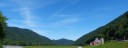 5
5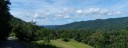 6
6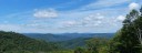 7
7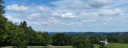 8
8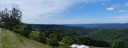 9
9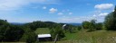 10
10 11
11 St. George to Macomber