


 1
1 2
2 3
3 4
4 5
5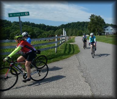
General Description
This ride is mostly on paved, unlined country roads with the exception of 2.2 on State Highway 62 thru New Haven. This route “rambles” thru the upper middle portion of Mason County. Only 2.9 miles (1.2 & 1.7 sections) of the route on County 12 is repeated. There are no really long climbs on the ride, but at 68 feet of climbing per mile, it is not flat. There is one steep climb that exceeds 15% in sections at the 16 mile mark. This is farming country, so there is not a lot of shade on the route. The best part of the route is the lack of traffic on these rural roads and the farm scenes.
The route can easily be shortened by eliminating some of the zigs and zags from the route. Taking Co. 1 and 7 returning from New Haven will take several miles off the route.
Route Description
Start:
The route begins at the West Virginia State Farm Museum. Probably best to park along the road outside the fence. There is a public rest room on the grounds of the Museum.
Farm Museum to County 9: Leaving the Museum, you head East and South on Co. 12 - 12/1 - 13 and 15/5 in rolling terrain. After passing the jct. with Co. 14 you begin an ascent on rough pavement and cross Co. 15 at 4.7 miles. At 6.8 miles you make a very sharp left turn to stay on 15/5 and be wary of the pavement at the bottom of the descent and the next couple of miles. At 9.6 miles you cross Co. 15 again onto Co. 7 which has pretty good pavement. After 1.1 miles on Co. 7 it connects with Co. 12 and at 11.1 miles turn right to continue on Co. 12. You have a slight climb and then turn right onto 12/8 Elia Road and at 13.6 miles you turn left on Couty 9.
County 9 to New Haven: After left on Co. 9 you will enjoy the good pavement and continue on Co. 9 for 4.2 miles with a short 0.6 segment it shares with Co. 12. At 15.3 you have a sharp left to follow Co. 9 north as Co. 12 continues straight. At the 16 mile marker you have the hardest climb on the route with gradient exceeding 15% in places, but a great view at the top. At 17.7 miles you turn left onto Co. 9/4 with has a fair amount of traffic, but good road surface. After 0.9 miles you turn right onto Co. 6 and for the next 2.1 miles the pavement is not good. You then turn left on State 62 which is a major 2 lane stripped road but you will shortly enter the reduce speed limits in New Haven. At 21.5 miles is a Convenience Store on the left. You will not want to pass this up as it is the only source of food and water on the route. You will want to top off the water bottles to finish out the ride.
New Haven to Co. 12: Leaving the convenience store in New Haven, you continue on State Route 62 till the 22.9 mile mark and make a left onto Co. 4 on a slight down grade. Be carefull when entering Co. 4 as there is often gravel on the road. Co. 4 has mixed road conditions and then you turn right onto Co. 3 and after 1.3 miles another right onto Co. 3/3 which has a decent climb on it. This is an area where you might encounter some Amish buggies or see them working the fields. At 29.8 you make a shape left on Co. 7, Sassafras Road and follow it till is runs into Co. 3 again, which you then follow to Co. 3/4. Making a right on Co. 3/4 you run into Co. 12 at the 34.7 mile mark and you make a right onto Co. 12.
Co. 12 to Museum: You follow Co. 12 back to the Museum, retracing part of the route to New Haven. At the 37.3 mile mark you make a right off of Sassafras Rd. to continue on Co. 12. The next 4 miles has less than ideal road surface. After passing thru part of the WMA and between a couple ponds, you make a right turn at 41.2 miles and have a 1.2 mile straight and slightly uphill run to the museum.