Texas Mountain Loop
Overview
 Length: 21.6
Climbing:1,510
Rating: 1.8
Climbing per Mlle.:70
Min. Alt.: 1,545
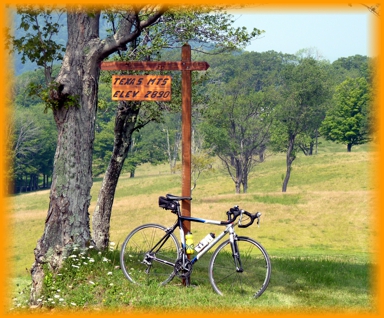
Max. Alt.: 2,879
Variance: 1,334
Location: This ride is in northern Tucker County, beginning in the community of St. George. The start is from the small community park at the end of the bridge over the Cheat River.
This is a short route, but with a challenging climb up Texas Mountain which offers great vistas.
St. George is a charming little community, that was the original county seat of Tucker County. There is a store (Patriots Four) at the intersection of routes 72 & 38. There is a community health center on Co. 1 in St. George. I have often stopped there to fill up my water bottles when on a ride in the area (closed on Sundays).
Limestone Mountain is another short loop from St. George and can be combined with Texas Mountain for a 42.4 mile ride with plenty of climbing. You will find the map and turn list for both rides included in the PDF Map and Turn List.
Of the two routes though, LImestone Mountain offers more vistas if that is what you enjoy.
I usually do this loop from camp at the Horseshoe Campground/Day Use Area, which makes it a 35 mile ride and adds another 850 feet of climbing.
PDF Map and Turn List
General Route Description
Taking a left out of the park, you cross the Cheat River, and turn right on state route 72. At 0.6 miles, you turn left on state route 38 and begin a gentle ascent along Clover Run. At 1.9 miles you turn left onto Co. 21 and begin ascending along the Left Fork of Clover Run. There is a medal deck bridge across Clover Run shortly after making the turn onto Co. 21. You will notice the road climbing more as you ride along the forested Left Fork of Clover Run. You go straight at the intersections to continue on Co. 21. At 6.7 miles, you pass the intersection with Co. 38 which comes in from the left. (Up to this point, you have been following part of the the Parsons-Kerens Loop route.) Shortly past the intersection, you will start following Indian Run and the road ramps up more. Where Co. 21 goes left as a gravel road and you continue on Co. 21/1 and the real climbing begins on this ride, From here to the summit, you have a steep ascent to the summit, exceeding 10% in places along 21/1 up to the intersection with Co. 19.
Arriving at the intersection with Co. 17, you bare left and have some flat and rolling riding for two miles to recover from the climb. You also get to enjoy some great views from Texas Mountain. At the intersection with state route 38, you take a right and begin a long, fairly steep descent down to Clover Run again. After reaching the bottom of the descent it is not long before you come to the intersection of Co. 21 again and close the loop. From here you have a nice gradual descent, retracing your route back to the start/finish.
Food and water sources.
There is a store, Patriots Four, that opened in 2013 near St. George (intersection of state routes 38 & 72) that is convenient to the bike route. Being new, I do not know the hours/days of operation. If you are going to depend on them as a source of food and water, I would contact them first.
Parsons has convenience stores open 7 days a week.
Items of Interest Along the Route:
The scenery is the main item of interest along this route. Most of the ride is along the mountain streams, except for the climb up and down Texas Mountain, which provides some great vistas.
Blackwater Outdoor Adventures is located in St. George. Combining this short ride with a kayak or canoe trip on the Cheat, makes a great day in the outdoors. They will take you 4 or 6 miles upstream on the flat water section, and you float back to their office. They also offer more adventurous outings on the river.
Patriots Four, is a new facility near St. George offering a general store, cafe, cabins, camping and outfitting services.
Local Sources
Nearest Bike Store: Blackwater Bikes in Davis, Tucker County.
Patriots Four has two cabins for rent as well as camping.
Horseshoe Campground, a national forest campground operated by the YMCA is open June, July, and August.
Area Attractions
Disclaimer
The listing of routes on this site is not a guarantee of the safety of the route. Cycling has inherent risks and riders skills vary. Traffic conditions vary by time of day, season and local events. Road conditions can vary and change and may change dramatically over one winter season. Riders need to ride within their capabilities and be alert for road hazards and traffic at all times.
Copyright Notice:
This site, maps, photos and all materials created for this site are copyright of the author unless otherwise noted. They may NOT be posted on other sites or reproduced for sale or profit, without specific permission of the author. However, the maps and turn lists may be down loaded for personal, non profit use.


 1
1 2
2 3
3 4
4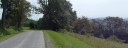 5
5 6
6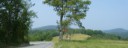 7
7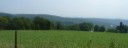 8
8 9
9 10
10