


 1
1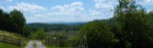 2
2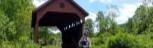 3
3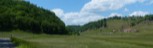 4
4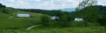 5
5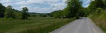 6
6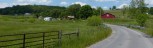 7
7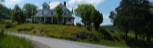 8
8General Description
This ride centers on the community of Greenville and could have been named the Greenville Loop, but you have to work so hard to get to Wikel, it seemed a more appropriate name. The high point of the ride is at Wikel. With the exception of the climb from route 122 to Wikel, riding the route in a clockwise direction is delightful. HOWEVER, you do have the climb to Wikel. From state 122, you climb 520 feet in the next 1.7 miles. That is an overall average of 5.7% grade, however, a mile of the climb averages over 11% with ramps up to 15%. But with the exception of this one climb, the rest of the route is easier in a clockwise direction.
Riding the route in a counter clockwise direction, you avoid the one long, steep climb to Wikel, but add some other short steep climbs getting to Wikel and also between Lillydale and Greenville.
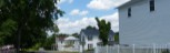
Start: Riding in a clockwise direction, Greenville is a convenient place to start. I park at the old school house out Schoolhouse Road. Another place to start would be at the vocatonal-technical school on Co. 219/17 at the southern end of the loop.
Riding in a clockwise direction from Greenville, you start upgrade on state 122, but quickly bare left onto Co. 23/4. 23/4 is worn tar and chip surface, so be careful on any down hills. After 3.5 miles on 23/4 you come to the Lillydale covered bridge. After riding thru the bridge, you have an easy climb and then a steep descent to Lillydale (more a name on a map then a community). 23/4 merges into 219/11.
You take a sharp right onto 23/5 and you have smooth ride on good pavement downstream along Back Creek to state 122 again. Going left on 122, you only go 0.9 miles before takng a right onto 23/7 Hunters Springs Road. You start out with a gentle climb before you hit the wall for the climb to Wikel. Continuing straight at the intersection at the top of the climb, you are then on Co. 219/17 and immediately begin what is primarily a descent all the way back to Greenville. Take time to enjoy some of the vistas as you descent from Wikel.
After passing the vocational technical school, you take a right past the old church onto Co.. 25. This is a beautiful road down the valley formed by Hans Creek before a gengle climb over to Cooks Run and a continued downgrade to Greenville.. Taking a sharp right at the intersection of 23/3, you cross a new bridge over Indian Creek for a final short climb up to Greenville. To the left at the end of the bridge, you can walk down to the old Cooks Mill. Climbing past the bridge into Greenville, you take a left out to State Route 122. A short detour in in Greenville
This slideshow follows the route in a clockwise direction