


 1
1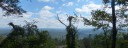 2
2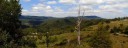 3
3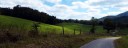 4
4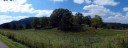 5
5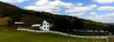 6
6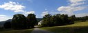 7
7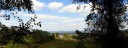 8
8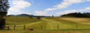 9
9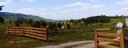 10
10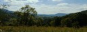 11
11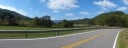 12
12General Description
This is a short loop, but the climbing makes it a workout. The route climbs out of the Greenbrier River Valley twice, first North of the river and then South of the river between Alderson and Fort Spring. Climbing rewards you with some great vistas and a great downhill run into the Wolf Creek drainage area on state route 3.. If you are looking for additional miles, try adding the Monitor Loop to this route.
Start: A convenient place to start is at the riverside park in Alderson along routes 3 - 12. Another place would be the train station across the river. Alternates: There are a couple churches in Fort Spring, and a church in Sinks Grove that would also make good starting places.
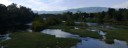
Alderson - Fort Spring: Leaving Alderson on route 12, you begin climbing almost immediately. Within a mile you turn onto Muddy Creek Mtn. Road and the real climbing begins. When you get to the shape S curves, the grades will often be above 15% for the next half mile. After managing this real steep sections, the grade across the rest of Muddy Creek Mountain runs a much more agreeable 4-8 percent. Just before you top out, there is a nice view North. Once you top out, you begin a very steep descent back toward the Greenbrier River. There are really 3 steep rams on the descent and a couple short flat sections breaking it up. There are some nice views South on this section. At the bottom of the descent, you bare right on State Route 63 for only 1/10 of a mile, before going left on Cty. 43. From this junction till the finish, you will be on the designated Wolf Creek Backway (map). Cty. 43 crosses the river on an open grate medal deck bridge so be careful crossing the bridge. Bare left at end of the bridge to continue on route 43 to Fort Spring. You are now riding on
Fort Spring to Sinks Grove: In Fort Spring, Cty. 43 makes a sharp right turn in front of the church and begins to climb out of the Greenbrier Valley. This climb is pretty sustained at 7-9 percent for a mile, before topping out. This climb gives you a good look at the interesting geological feature of the Fort Spring oxbow. The Greenbrier River used to make a large loop thru the valley below, but eventually eroded thru the neck forming what is know as an oxbow.
Shortly after topping out, you take the first right off of Cty. 43 onto Cty 58. After 0.9 miles you take a left just past the Mt. Vernon Church onto Cty. 58/1 Longanacre Road.. Longanacre Road takes you along the base of Flat Top Mountain on a rolling and overall gradual upgrade. After 2.1 miles, you go right onto Cty. 42/3, which soon becomes Cty 5/2 as you cross from Greenbrier into Monroe County (no marker). 5/2 continues along the base of Flat Top mountain before heading East and connecting into Cty. 5 near Sinks Grove. At the junction with Cty.5, you take a right and climb a little before a steep descent into the little community of Sinks Grove. You might want to take the old route by the church down thru the community. At the junction with State Route 3, you take a right and follow route 3 into Alderson.
Sinks Grove to Alderson: Leaving Sinks Grove, heading West on route 3, you start climbing thru some beautiful farms. You have a couple short climbs and descents before arriving at the brink of the Wolf Creek drainage area. This is just after passing the junction with Cty. 1, Flat Mtn. Road. If you want to add more climbing, you can take Flat Mtn. Road into Alderson from here, but the route continues on State Route 3. If you enjoy downhills, the descent into the Wolf Creek drainage is a joy. There are some sharp turns, so ride under control, but you have a couple miles of downhill to enjoy. Once you get to the bottom you will enjoy some fun flat riding for the next few miles, with one little climb to spoil the roll along the edge of the valley. When you pass the junction with Cty. 3/2, you begin the last climb of the ride. This climb is not bad and you roll along the top before a steep final descent to Alderson. When you arrive in Alderson, you continue straight across the pedestrian bridge and take a right to get back to the riverside park.
The bikemap.net program would not let me take route across the pedestian bridge, so it reads a little longer. Click on "Route 2,365,452" at bottom of window to go to the route. You can download a GPS track of the route from the site.
Route Options:
- You can take Cty. 43 and Cty 5 between Fort Spring and Sinks Grove rather then Longanacore and Scott Hollow Roads.
- Route 63 between Alderson and Fort Spring has high speed traffic and a road I generally avoid,
- This route can be combined with the Clayton Loop or the Lowell - Johnsons Crossroads Loop for a longer ride.
- Monroe Cty.. 1, Flat Mtn. Road is a hil