


 Looking toward Woodrow and Edray
 The Scenic Highway is on the mountain in the distance.
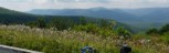 2
2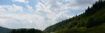 3
3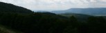 4
4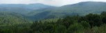 5
5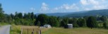 6
6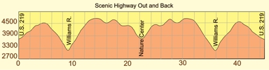 Length: 45 miles
General Route Description
This route is a challenging out and back on the Highland Scenic Highway, State Route 150, as can be seen in the profile above. It features great vistas and long climbs and descents in both directions. Because a lot of the ride is on the mountain crest, weather and wind can be extreme at times. The trees are kept trimmed back from the road, so you have no shade from the Sun and little break in windy conditions, but great vistas in clear conditions. The climbs tend to be steady with little variation in gradient. There are few sharp turns to worry about on the descents, but you need to control your speed, while watching not to overheat your tires. One thing riders with disk brakes do not have to worry about.
Start: Intersection of U.S. 219 and State Route 150, 7 miles North of Marlinton. Alternate start would be the Cranberry Mountain Nature Center at the intersection of State Route 39 and State Route 150. Starting at the U.S. 219 end allows you to use the Nature Center as a mid-ride rest point and water stop. There are no stores or other water sources along the route.
Route 219 to Cranberry Mountain Nature Center: From the parking area, you start with a 3.7 mile climb up the side of Red Lick Mountain. You will pass one pull out overlook with a restroom on this climb. At 4 miles, you will start past Red Spruce Knob (4,703') on the left, with a great vista to the right. At 6 miles, there is another pull out overlook (w/toilet) just before starting the 3 mile descent to the Williams River Road. At 9 miles, you cross the Williams River and begin the 5 mile ascent of Black Mountain. After toping the climb, at 14.3 miles you will pass another pull out overlook (w/toilet). At 16 miles you pass another pull out overlook (w/toilet). At 17.5 miles, you pass the parking area for the Cranberry Glades Overlook. At 20.5 miles, you begin the final descent to the Cranberry Glades Nature Center that is located at the intersection of State 150 and State 39. At 22.5, you will be at the door of the Nature Center, where you can get water if they are open.
Cranberry Mountain Nature Center to Route 219: Leaving the Nature Center you begin climbing almost immediately to the 25.4 mile mark. You continue a more gradual ascent till passing the 28.3 miles. At 29.3 miles, you are passing the first of the pull out overlooks on your return. At 31.0 miles you past the second overlook and at the 32.0 you begin the five mile descent down Black Mountain to the Williams River. At 36.3, you cross the Williams River and begin the 3 mile climb up the other side. At 40.5 miles you top out the climbing and head past Red Spruce Knob and begin the descent to U.S. 219.
Food-Water Sources:
The only water source along this route is at the Cranberry Visitors Center at the intersection of the Scenic Highway and state route 39. There is a convenience store at Edray on U.S. 219, 31.6 miles from the start.